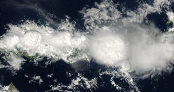
While passing over the Indonesian island of Flores on December 2, 2013, the NASA Aqua satellite was able to use its Moderate Resolution Imaging Spectroradiometer (MODIS) instrument to capture an amazingly-detailed view of thunderstorms rolling past underneath.
Usually, satellite images of clouds are not that relevant, since the atmospheric features look flattened and appear to fly at sea level. The angle of the MODIS instrument in this particular case however enabled scientists to observe the size, texture, and height of these large clouds.
According to NASA scientist Joseph Munchak, this image clearly shows how rapidly rising air from the surface is fueling the intensity of the storm and the size of the mushroom clouds. “This looks like a classic example of island convection that is enhanced by topography,” the expert explains.
NASA planned to use the MODIS instrument on its Terra satellite to capture an image of the storm before Aqua's pass overhead, but the clouds had not yet fully developed. According to precipitation experts, the type of atmospheric convection is most powerful in early afternoon, which coincided with the time of Aqua's pass.

 14 DAY TRIAL //