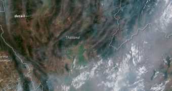
A NASA satellite captured this frightening view of portions of southeastern Asia earlier this month, showing a massive cloud of smoke and haze covering portions of Burma, Laos and most of northern Thailand.
The cloud is believed to originate in massive agricultural and forest fires in the area. The NASA Terra satellite captured the view using its Moderate Resolution Imaging Spectroradiometer (MODIS) instrument, on March 4, 2012.
A large band of pollution is also visible across central Thailand. The fact that the southeastern Asia's dry season occurs during late winter and early spring contributed to the extent of the devastation.
The massive haze prompted the Lampang airport to experience significant disruptions in its air traffic, and brought particulate matter levels in the air to extremely dangerous levels. A heavy rain storm on March 11th and 12th reduced the severity of the situation considerably.

 14 DAY TRIAL //