14 DAY TRIAL //
 If the temperature and the pressure of the air in the Earth's atmosphere would be uniformly distributed on the surface of the planet, there would be no movement of the air. However, the reality is somehow different. The excessive heating of some areas on the surface leads to an uneven distribution of the temperature of the air, which is the main cause for the uneven distribution of atmospheric pressure across the surface of the Earth.
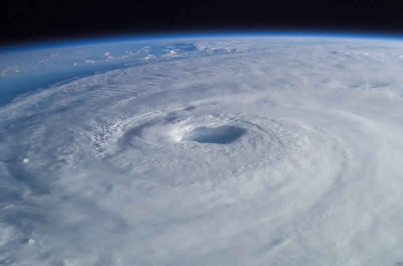
This uneven pressure is what drives the movement of the masses of air in the Earth's atmosphere, from an area with higher atmospheric pressure to one with lower pressure. This way, air is being circulated on a horizontal direction, the so-called wind. When the wind reaches speeds of 30 to 50 meters a second, it becomes a hurricane or a cyclone.
In meteorology, the line of separation between two air masses with different characteristics is called a frontal zone. It can be identified through a striking discontinuity in the distribution of all the elements and meteorological processes. The frontal zone can reach widths between 10 to 20 kilometers and heights between 1,000 to 2,000 meters, sometimes even 6,000 to 18,000 meters. This is where the interaction between two masses of air with different properties takes place.
The warm air follows an ascending trajectory in relation to that of the cold mass of air. Through such movement, the air is being cooled until condensation of water vapors takes place, thus enabling the formation of rain and snow clouds - depending on the geographic region. Similar atmospheric phenomenons can be routinely experienced over the regions of the Atlantic ocean, and are transported over the European continent were they release most of their energy before fading away.
Such a phenomenon took place on the 15th and 16th of October, 1987, for example, when multiple countries in the western regions of Europe were hit by gusts of wind with speeds up to 220 kilometers per hour. The storm raged more than 7 hours over the regions of Great Britain, tearing off trees, killing animals and producing extensive material damage. The damage was estimated to 2 billion pounds. A year later, the same phenomenon produced extensive damage in the Corsica island.
Meteorological institutes found themselves incapable of making predictions. Nonetheless, researchers were able to find the origin of the storm. It was estimated that the hurricane that occurred on 15-16 October, 1987, originated somewhere above the Azore island, when a mass of air averaging a temperature of 22 degrees Celsius met a mass of air with a temperature of 5 degrees Celsius originating in Greenland. The movement of the two masses of air determined a turbionary effect that created a depression.
Hurricane prediction
Several other hurricanes that took place in the next years made the prediction of such atmospheric phenomenons an important objective for most of the meteorologists in the western Europe. "Front '87" was a research program using 15 meteorologic radars, that created a map of precipitations with a radius of 150 kilometers, each 30 minutes. Further still, all meteorological stations across western Europe launched a weather balloon every three hours, in order to measure the atmospheric pressure, temperature, humidity and speed of wind.
Additionally, meteorologic stations in Brest, Lorient and Lannion launched balloons every 90 minutes for enhanced precision. The French coast was being patrolled by aircraft with a flight autonomy of four hours, measuring the air turbulence in friction areas. At the same time, radar devices mounted on the fuselage measured the air speed and precipitations. Rain droplets falling to Earth were measured with the help of laser beams.
Once surveillance missions were over, the recorded data was introduced into a computer in order to be processed, so that meteorologists could make accurate predictions.