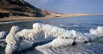
Lakes are classified depending on how they formed and on the quality of the water (freshwater or saltwater). Only in the saltiest lakes there is no life. Lakes contain 4 times more freshwater than the rivers, but, if they are not continuously supplied with freshwater, they can disappear through dessication or accumulation of sediments.
1.Tectonic lakes. The movements of the Earth's crust formed the largest lake, the Caspian Sea, and the deepest, Lake Baikal. Caspian Sea is located in a depression between the Caucasus Mountains and Central Asia and its surface is still varying, millions of years after its emergence. Before the formation of the Caucasus chain, it was connected to the Black Sea.
Lake Baikal (in Siberia) emerged after the collapse of a tectonic block that formed a depression, subsequently filled by water.
The Great Rift Valley in Africa harbors, from north to south, a chain of lakes like Albert, Edward, Tanganyika and Malawi. The rift penetrates to southwestern Asia, comprising the lake located at the lowest altitude: the Dead Sea, 399 m (1,330 ft) under the sea level.
2.Volcanic lakes. The most common form is the one filling the caldera of a shut-off volcano. One of the largest lakes of this kind is the Crater Lake, from the crater of Mazama Mountain, Oregon, US. It formed 6,600 years ago, having 10 km (6.2 mi) in diameter, and a depth of 589 m (1.963 ft).
Some volcanic lakes form when the lava seeps on the slopes, solidifying due to the cold waters. This way the Lake Kivu from the Great Rift Valley formed, located between Rwanda and Zaire. Its valley had had a northward flow to the Nile, which was blocked by the eruption of a local volcano. Now, the waters of the Lake Kivu are drained by the Ruzizi River into Lake Tanganyika.
3.Glacial lakes appear following the melting of the glaciers. They are more common in the Northern Hemisphere, due to the Quaternary glaciation. Most lakes in the UK, Finland (about 60,000 !) or Alps formed this way.
The glaciers dug deep pools on the rocks on which they formed, which filled with water after their melting. The debris deposed by the glaciers caused the interception of some valleys and, finally, the forming of lakes.
4.Karstic lakes form in calcareous regions and can be subterranean as well. Water dissolves the limestone creating huge caves harboring rivers and lakes. Lakes in regions with subterranean salt deposits appear in a similar way.
5.Salt lakes. Most lakes contain freshwater and are continuously supplied with water from the exterior. If the supply of freshwater is limited, minerals from the bottom of the lakes can enter into the water's composition and concentrate, turning the lake salty. The Great Salt Lake from Utah formed this way.
The Caspian Sea and the Aral Sea are salty too. The Aral Sea was once the fourth lake in the world, but the exploitation of the water of the rivers supplying it caused its surface to drop from 77,541 square km to 40,000 square km, placing it on the sixth position in the world nowadays.
The saltiest lake in the world is the Dead Sea, located between Israel and Jordan; its salinity is 9 times higher than the ocean's. Because of this, the human body floats at the surface of its waters, without the need to swim.
In many places, like Africa, the Andes or Galapagos, the salty lakes are used for salt extraction during the dry season.
6.Artificial lakes. The most common are reservoirs, like Lake Nasser, formed through the interception of the Nile, and Lake Mead (US), formed through the interception of the Colorado River. They generate hydroelectric power. Many artificial lakes serve as water reservoirs, supplying water for industries and home usage.

 14 DAY TRIAL //