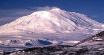
The Gamburtsev mountain range is one of the most visited destinations in Antarctica, because it offers a rich ground for scientists to conduct a large series of experiments in the most varied of research fields. In one such experiment, scientists have used radars to map the terrain underneath the ices, and get a glimpse at how the ice first formed in the area, some 14 million years ago. Underneath the massive ice sheets of East Antarctica, the investigation team uncovered amazing peaks and valleys, which riddle the region from one end to the other, and make for an exquisite, albeit invisible, mountain landscape.
In a paper covering the finds, published in a recent edition of the prestigious scientific journal Nature, the team writes that the new finds could help experts better predict the influence of global warming on the ices, and on their melting patterns. Fausto Ferraccioli, a British Antarctic Survey (BAS) scientist who conducted other experiments in the area, said that “This is the largest reservoir of ice on Earth, and the most poorly understood place on our planet,” BBC News informs.
The expert underlined the fact that the Gamburstev mountain range is located in the middle of the ice sheet, and, as such, it might have been the best place on which the original ice could settle. It may be the case that the water first froze alongside the slopes of the mountain, and then advanced in the surrounding valleys, and in other landscape features as well.
In the new research, China-based Polar Research Institute expert Sun Bo drove more than 1,235 kilometers (767 miles) in a tractor train with his team, dragging behind state-of-the-art radar equipment. When they reached their designated study location, the Dome A region, in the middle of the mountain range, they carefully surveyed a 30 km x 30 km square, basically drawing a picture of what lies beneath. They found a landscape remarkably similar to that the Alps have today.
“This is true scientific exploration. There's nothing to guide you really. Peering down at the ice sheet beneath your feet, you just don't know what's under there,” said one of the team members, Dr. Martin Siegert, who is the Head of the School of Geosciences at the Edinburgh University, in the UK. “You just measure the two-way travel time as they go down and come back up again. Then you can convert that to ice thickness, because you know the velocity at which [the radio waves] are traveling.”
“There's been a lot of climate change over the last 14 million years. And what we can say about this place in the middle of the Antarctic is that nothing has changed. [The research] puts the ice sheet into the context of global climate and what conditions are needed to grow an ice sheet. The worrying thing is that we seem to be going back to carbon dioxide concentrations consistent with there being a lot less ice around,” Siegert concluded.

 14 DAY TRIAL //