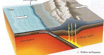
The theory of the plate tectonics and continental drift was accepted in the '60s, when the proofs came from the ocean. Earth's external layer is called lithosphere. It is a rigid blanket with a thickness of about 100 km (62 mi). It includes both the oceanic platform and the continental crust, but also the upper part of the mantle, the layer located under the crust. Between the crust and the mantle, the Mohorovici (Moho) discontinuity is found. Under the solid mantle, the asthenosphere, the plastic or semi-molten part of the mantle is found, at depths of 100-200 km (62-125 mi).
The oceanic platform is much thinner than the continental crust (6-7 km or 3.7-4.1 mi compared to 30-40 km or 19-25 mi) and formed almost completely in the last 200 million years. The continental crust is much thicker and in some places it is 3 billion years old.
Under the sediment layers of the oceanic platform, a solid rocky dark layer is found, going down to the surface of the mantle. This is Sima, rich in silicon and magnesium. The continental platform is made mainly by a lighter rock, rich in silicon and aluminum Sial. Sial is located over Sima.
Most of the oceanic platform is flat, excepting submarine mountain chains and abyssal sinkholes. The oceanic mountains form chains up to 80,000 km (50,000 mi) long and 4,500 m (15,000 ft) high. The Atlantic mountain chain goes from Iceland to the islet of Tristan da Cunha, in southern Atlantic. The chain surround the Good Hope Cape to join the mountain chains of the Indian and Pacific oceans.
All the marine mountain chains have a crack in the middle, about 50 km (31 mi) wide and 2 km (1.2 mi) deep. Sometimes the submarine mountains go to the surface of the water, forming islands. Iceland is the largest island appeared this way. Isolated volcanic mountains, submarine mounts may exist as well.
In 1960, a new theory stated that the oceanic platform is in a continuous expansion due to the submarine mountains. New oceanic crust grows with several cm annually, rapidly enough to explain why the whole oceanic platform is just 200 million years old.
But the Earth does not grow: the same amount of oceanic crust descend through abyssal sinkhole back into the mantle. The deepest abyssal sinkhole is that of the Marianas Islands (near the Guam Island in the Pacific): 11,033 m (36,776 ft) deep.
The motion power for moving the crust is supplied by the convection currents of the mantle. The convection currents are circulatory movements produced in a liquid or plastic substance, similar to those seen during the boiling of a porridge and caused by the growing temperature. The heat flows and the speed with which the heat raises to the surface of the Earth is very high along the submarine mountain chains. It decreases gradually as we distance from the mountains and it is very weak in the abyssal holes.
First proofs came in the '60s. The oceanic platform was found to have alternative, weak and strong, magnetic bands. They could formed only if the magnetic field of the Earth changed periodically its polarity, so that the magnetic north turned into the magnetic south. The alternative blocks of normal and inversely polarized material slipped by one side and another of the mountain chains, being placed parallel to it. Later, it was found that all the rocks that formed at the same date had the same polarity, and an algorithm of the magnetic polarity change was found.
The research of the rocks near the medial Atlantic chain showed the Atlantic widens by 4 cm (1.6 in) annually. Today, the Atlantic is with 80 m (270 ft) wider than during Jesus' times. The Red Sea is formed in a crack into the lithosphere and the crack goes from the African Rift to the Dead Sea. In the future, the African Rift could turn into an ocean. The Red Sea has a submarine mountain chain that widens it by 2 cm (0.8 in) annually, distancing Arabia from Africa.
15 main tectonic plates exist on Earth, besides numerous smaller plates. The plates are separated through submarine mountain chains. The submarine mountain chains and their valleys represent fracture areas. On both sides of the chain, the plates distance one from the other in opposite directions.
Abyssal holes represent the place where two plates meet. While one plate is consumed, absorbed in the mantle below, the other is pushed up forming mountains, volcanoes and earthquake areas. The place where one plate sinks is called 'subduction area'.
Some plates are delimited through transformation crevices (conservative delimitation), through which material is not added or taken from the lithosphere. This is a right-angle fracture of a constructive edge. Oceanic chains do not represent a straight line, being often placed to the right or to the left, while the plate adapts to its own movement.
Plate delimitations are not always parallel to the joints between the oceanic and the continental platform. They include both types of crusts and many meet under a different angle. Some plates slide one over the other when they meet, like in the western shore of the US, where plate delimitation is marked by the San Andreas crevice. This is one of the most dangerous areas in the world. When two plates move obliquely one towards the another, the movement won't be stable, constant. The friction between the two plates can be temporarily blocked, but when it gets stronger, to overcome the friction, the blockage will be removed as a catastrophic earthquake.
The main motion force is not the push from the mountain chains, but the pull from the subduction areas, where the old ocean crust is swallowed back into the mantle to be recirculated.

 14 DAY TRIAL //
