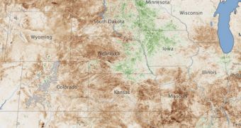
Experts recently used the Moderate Resolution Imaging Spectroradiometer (MODIS) instrument on the NASA Terra satellite to image the extent of the massive drought currently affecting the United States.
Statistically speaking, the adverse weather currently amounts to a drought of historic proportions, affecting corn, soybeans and wheat crops in 1,000+ counties in 26 states across the country. The US Department of Agriculture on July 11 designated these counties as natural disaster areas.
“The extent of the damage to crops is depicted in this vegetation anomaly map. The map contrasts plant health in the central United States between June 25 and July 10, 2012, against the average conditions between 2002 and 2012,” NASA reports.
A report by the UN Intergovernmental Panel for Climate Change shows that the international scientific community has a “medium confidence” that the current extreme weather patterns are caused by human activities that lead to global warming and climate change.

 14 DAY TRIAL //