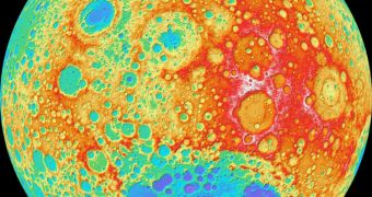
A new high-resolution image of the lunar surface was just released by investigators in charge of the imaging cameras aboard the NASA Lunar Reconnaissance Orbiter (LRO). The view includes only a year's-worth of data, and covers nearly the entire surface of Earth's natural satellite.
Astronomers say that this dataset has the highest resolution of any other created for the Moon. The LRO is therefore moving one step closer towards completing its main objective, which is to find a suitable landing spot for future manned mission to the lunar surface.
Originally, the space probe was supposed to act as a spy for Project Constellation, the American space agency's lunar-oriented program. However, since the project was scrapped by the Obama Administration back in 2010, the spacecraft is now strictly a scientific mission.
Its onboard camera system is one of the most exquisite even sent to space, and therefore capable of conducting high-resolution imaging sessions above the lunar surface. The newest image is created at a resolution levels of around 100 meters (328 feet) per pixel.
Scientists from the Arizona State University (ASU), in Tempe, are the main investigators for the LRO Camera (LROC) instrument, the main imaging system aboard the spacecraft. The LRO Wide Angle Camera and the Lunar Orbiter Laser Altimeter (LOLA) instruments were also a part of the study.
“Our new topographic view of the Moon provides the dataset that lunar scientists have waited for since the Apollo era,” ASU LROC principal investigator Mark Robinson explains. “We can now determine slopes of all major geologic terrains on the moon at 100 meter scale,” he adds.
In addition, scientists can now also “determine how the crust has deformed, better understand impact crater mechanics, investigate the nature of volcanic features, and better plan future robotic and human missions to the Moon,” the expert goes on to say.
ASU investigators say that it took more than 69,000 WAC stereo images to piece this composite picture together. Among themselves, the images cover latitude ranging from 79°S to 79°N, which represents about 98.2 percent of the surface of the Moon.
Since the dataset is not complete, it stands to reason that it may be augmented with yet more data in the near future. In fact, experts plan to include another year's-worth of data in the model as soon as the information becomes available.

 14 DAY TRIAL //