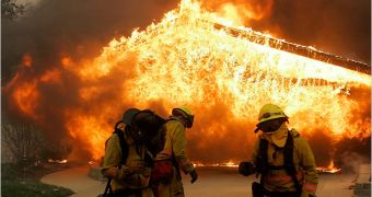
Out of control fires this late October rampaging through California didn't wield shovels and houses, but rather high-tech technologies developed at the University of California. The use of these tools not only helped the region respond and recover, but save lives as well. These unpredictable fires exploit the full vulnerability of the population and rescuers who often get confused in the baking blaze and cannot efficiently respond to other help calls.
While the fire was moving toward the populated regions, researchers at the California Institute for Telecommunications and Information Technology (Calit2) collaborated with NASA in an effort to create detailed images, provided by satellites and link directly to the maps of the areas in which firefighters were trying to control the fire and evacuating the people ahead of the flames. Ramesh Rao of the UC San Diego division of Calit2 led the work to create an overlay on a Google map. The users could then connect via the Internet to see high-quality video feeds in real time.
The High Performance Wireless Research and Education Network own fifteen of the eighteen cameras that record the video images. One of them was placed in a remote part of the country to capture the firestorms and revealing how any tiny trail of smoke could ignite into a huge wildfire. The advantage of such tools is that cameras can show the researchers what is going on in a selected region, even before the firefighters can get there.
Also with the help of the San Diego Supercomputer Center, over a quarter-million people have been evacuated through Southern California. The collaboration between SDSC and the American Red Cross started during the Hurricane Katrina to help people find each other in wide areas and evacuations. Once the fires started to get out of control, the site which allowed people to see images of the affected areas was quickly opened.
Air quality has been closely monitored, since it has critical importance to the firefighters operating in the disaster areas. A study made by Kim Prather of the Scripps Institution of Oceanography, one of the researchers there, observed effects from the ground, sea and space. The data collected from the 2003 wildfires significantly contributed to the rise of greenhouse gases, representing three to seven percent of the entire state's emissions in that year.
These technologies, the innovative research of UC San Diego inflicted immediate benefits for the people of San Diego during this year's wildfires.

 14 DAY TRIAL //