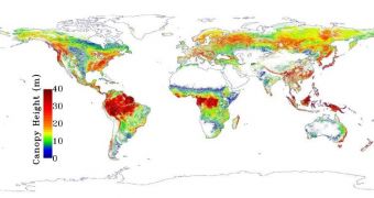
The fact that forests are extremely important for regulating our planet's atmosphere is no secret, but researchers are still having trouble grasping the full extent of this involvement. A new map developed by NASA experts, covering global tree height levels, should help with clearing up this mystery.
A group of investigators led by scientists at the NASA Jet Propulsion Laboratory (JPL), in Pasadena, California, used data from the American space agency's Ice, Cloud and land Elevation Satellite (ICESat) mission for this investigation.
The Geoscience Laser Altimeter System (GLAS) instrument aboard the spacecraft collected LIDAR (light detection and ranging) data covering the world's forests back in 2005. Researchers then pieced the datasets together to create this accurate, high-resolution map.
Researchers say that the product will help them determine how wildlife forms habitats and ecosystems within forests. In turn, this will help experts figure out how to better conduct conservation efforts.
In addition, the map could be used to quantify the amount of carbon that is currently sequestered in forests around the world. This is a very important quantity to know, considering that deforestation now releases massive amounts of carbon dioxide into the atmosphere.
In addition to the JPL group, scientists from the University of Maryland in College Park, and the Woods Hole Research Center in Falmouth, Massachusetts, were also involved in the research effort.
A total of about 2.5 million laser pulse measurements covering the entire planet were centralized in this map. “Knowing the height of Earth's forests is critical to estimating their biomass, or the amount of carbon they contain,” JPL scientist and lead study researcher, Marc Simard, explains.
“Our map can be used to improve global efforts to monitor carbon. In addition, forest height is an integral characteristic of Earth's habitats, yet is poorly measured globally, so our results will also benefit studies of the varieties of life that are found in particular parts of the forest or habitats,” he adds.
The team also used field data collected from about 70 research sites around the globe to validate the ICESat measurements. The map's spatial resolution was thus brought down to 0.6 miles (1 kilometer).
As general trends, forests tend to be highest at lower elevation, and decrease in size proportional to increased altitudes. In addition, it was observed that forests closer to the tropics were higher than those at higher latitudes.
Details of the study were published in a recent issue of the esteemed Journal of Geophysical Research – Biogeosciences.
“Our map contains one of the best descriptions of the height of Earth's forests currently available at regional and global scales. This study demonstrates the tremendous potential that spaceborne lidar holds for revealing new information about Earth's forests,” Simard concludes.

 14 DAY TRIAL //