14 DAY TRIAL //
 Google may be a leader in Internet technologies, but its success has allowed the company to redirect some of its resources to fund environmental or philanthropic projects through its non-profit arm Google.org. One of its latest projects was revealed today at the International Climate Change Conference (COP15) which is underway in Copenhagen. The project aims to help countries and organizations with interest in the field visualize and measure the extent of deforestation in problematic areas all over the world.
Google says that deforestation in tropical areas is one of the major sources of carbon emissions greater than the cars, trains, planes and ships in the world. Studies in the field have show that stopping large scale deforestation is an easy and cheap way of cutting down on emissions worldwide.
“The United Nations has proposed a framework known as REDD (Reducing Emissions from Deforestation and Forest Degradation in Developing Countries) that would provide financial incentives to rainforest nations to protect their forests, in an effort to make forests worth "more alive than dead." Implementing a global REDD system will require that each nation have the ability to accurately monitor and report the state of their forests over time, in a manner that is independently verifiable,” Rebecca Moore, engineering manager and Dr. Amy Luers, Environment Manager at Google.org wrote.
There is a problem though, many of those countries don't have the technology or the resources to provide accurate measurements required to be included in the project. Google decided to help with the matter and has come up with a solution which, despite being in the early stages, could prove very useful down the line.
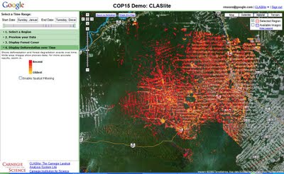
Satellite photos are a great resource for tracking deforestation over time and Google Earth already has images from different periods in time which make it easy to see the extent of the problem. But, there was a need for a way to have actual quantifiable measurements rather than just a visual tool, so Google partnered with Greg Asner of Carnegie Institution for Science, and Carlos Souza of Imazon, both of which have software to measure and analyze deforestation based on satellite imagery.
However, the software solutions depend on the quality and the amount of imagery they can process which has been a problem so far. Luckily, Google can provide access to a huge library of satellite data but also to its vast processing capabilities, so it got the two scientists to create versions of their software which would run in the Google cloud.
Google says this approach has several big advantages over other implementations which make it very suitable for the task of allowing countries to monitor their forests. Using Google's hardware resources the data can be analyzed in seconds removing the need for a dedicated infrastructure to handle the task. Also the data is a lot more accessible since it's available online and viewable through any browser. The tool isn't available to the public yet, but Google says it will release it over the next year.