 14 DAY TRIAL //
 Google Maps is surely one of the most accessed Internet services because it allows users to view satellite maps and other imagery with the entire world directly from the official page of the service. Although the search giant owns one more similar product, Google Earth, a downloadable application that provides almost the same functions as the web-based service, Google Maps remains an attractive solution for all the users that are looking for satellite maps. It's obvious the two products are very popular because even terrorist were using them to organize attacks against UK troops located in Basra. At that time, the company repaired the issue by replacing certain images with older ones captured before the departure of the army in the area.
Because Google Maps is very important for both users and company, the search giant's employees tried to improve it periodically to bring the product in the spotlights. The last improvement presented some days ago concerns the information displayed by Google Maps that sustains the service now offers subway stations for certain US locations.
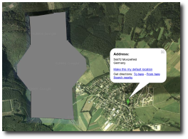
Today, Philipp Lenssen from Google Blogoscoped posted an article on the blog to report a weird image displayed by Google Maps. The service shows a gray shape that looks like a censorship but the blogger sustains there is nothing important in the area.
"While it may look like censorship at first, it might also be just missing data, or be due to something entirely different. Because my father, who found this, asked my grandpa, who lives near-by the location, what's in that area, and the answer is: nothing. At least nothing suspicious - there's just a road there dubbed Kaffeestrasse (coffee street). My grandpa added that he also saw this issue being pointed out in a reader mail to a local newspaper. Apparently, the gray blob has locals scratching their head, too," Philipp Lenssen from Google Blogoscoped mentioned in an article posted on the official site.