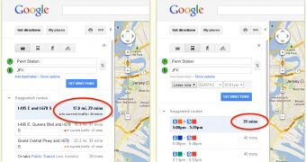
Google Maps has just gotten new travel time estimates that take into account traffic conditions. If you're getting a feeling of deja vu, you're right, the feature, a similar one in fact, was available in Google Maps up until about a year ago.
It's now back and better than ever. When planning a trip, you'll get the usual travel time estimate, based on ideal conditions, but also an adjusted number that takes into account current traffic conditions.
This way, if the streets are really packed you may find the subway faster, even though that wouldn't normally be the case. The really interesting and useful part is that the estimates are based on real-time and near real-time data, so they should prove rather accurate.
"Now using both live and historic traffic data, Google Maps enables you to once again see the estimated length of time your journey might take," Google announced.
"In areas where the information is available, this new and improved feature evaluates current traffic conditions and is constantly being refreshed to provide you with the most accurate, up-to-date estimate possible," it explained.
The previous version of the feature, which Google shut down since it was unpleased with its performance, predicted traffic-adjusted travel time based on historical data and provided a worst-case scenario which was less useful than the current feature.
Of course, the feature is only as useful as the data it's relying on. And that data is location data from Android phones.
Not just any Android phone, Android phones that have Google Maps (most of them do) with the GPS enabled, with a data connection active and whose owner opted into the My Location feature. Unfortunately, this will mean that there won't be enough data for the feature to work in plenty of places. Google does rely on third-parties for some data though.

 14 DAY TRIAL //