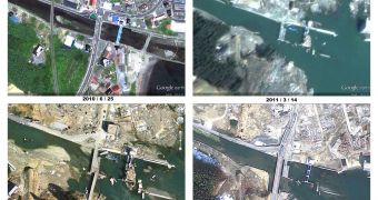
It's been a year since the devastating earthquake and subsequent tsunami that hit Japan and the areas affected are still recovering. The damage was extensive, even total in some areas.
The country is still rebuilding and Google has provided an updated set of satellite imagery for the regions affected, taken recently, in February and March this year, through which you can see the progress for yourself.
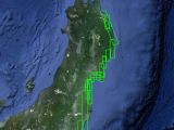
"The new imagery covers the Northeastern coast from Hachinohe in Aomori Prefecture down to Hitachi City in Ibaraki Prefecture. This high-resolution imagery from GeoEye was taken in February and March and provides a telling view of what the affected areas look like a year into recovery," Google explained.
Google has been providing updated imagery for the area on a regular basis since the tragedy, giving those living in the area and those interested in keeping up with the process.
The new imagery is already live on Google Maps, so you can just jump in and go to any of the affected areas to check it out.
There are still plenty of signs of the disaster, but there's also plenty of evidence of the work being done on rebuilding. In some places, the recovery can be quite impressive.
You'll get an even better picture in Google Earth though since you'll be able to check out all the previous, historical imagery as well, providing a step-by-step view of the work being done, but also of what the cities, villages and so on, used to look like.
"Since the earthquake and tsunami last March 11th, we have been updating satellite and aerial imagery of the area to show the effects of the disaster as well as the pace of rebuilding. The new imagery shows that the road to full recovery is still long. There are, however, signs of progress — from large trucks on the streets to newly repaired bridges and bustling ports," Google added.

 14 DAY TRIAL //
