Google is launching the Public Alerts feature in Taiwan, just ahead of the typhoon season. The service, as the name suggests, is dedicated to sending public alerts from the regions the service is available in.
Google uses the data from the service, which comes from various national agencies, across several of its products like search, Now, and Maps.
"As Taiwan heads into another Typhoon season, the need for reliable and easily accessible information about where the next storm will hit and how to stay safe has never been more important. That’s why we're launching Google Public Alerts and a dedicated Google Crisis Map for Taiwan," the company announced.
In the case of an emergency, alerts will be displayed on the search results page for relevant queries in the region. They will also show up in Now, in the form of a special card, and in Google Maps if you're looking at the area affected.
Public Alerts is available in several countries already. What is interesting though is that Google is also launching a Crisis Response Map along with support for public Alerts in Taiwan.
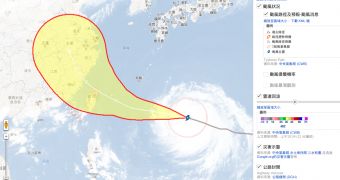
Normally, Crisis Response maps are put together as needed, in the case of floods, fires, earthquakes, storms, and so on, and it's no different this time, as there is a typhoon headed straight for Taiwan and onwards to mainland China.
It's going to be three more days before typhoon Huaning, or Soulik, as it's known internationally, hits Taiwan, if it doesn't change course in the meantime, but the crisis map should prove useful for planning in the case of an actual emergency.
The crisis map shows shelter locations, weather data and various other useful pieces of information. The Taiwan map uses data from Central Weather Bureau, Water Resource Agency, Soil and Water Conservation Bureau, Directorate General of Highways, and the National Science and Technology Center for Disaster Reduction.

 14 DAY TRIAL //