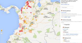
The Google crisis response team started as just that, several people at the company responding to various disasters around the world by building maps with information or tools like the Person Finder.
But, more recently, Google has taken a full-on responsibility and is constantly monitoring for emergencies.
In fact, it has started out building response maps for countries even if there aren't any current emergencies. After it debuted such a map for Australia, it's now introducing one for Colombia as well, along with a new public alerts system.
"We’re launching Google Public Alerts and Crisis Map in Colombia to provide people with access to useful information before, during, and after a natural disaster such as a tropical storm, hurricane, flood or landslide," Google explained.
Google teamed up with the Colombian Institute of Hydrology, Meteorology and Environmental Studies (IDEAM) and the National Unit for Disaster Risk Management (UNGRD) to provide the data for the crisis map and the new public alerts system.
Via Google public alerts, notifications and warnings about various emergency situations can reach the people that need them the most. The notifications show up in Google Maps, when you're looking at the affected area.
They're also displayed in Google Search when you're looking for information about the emergency. Finally, they're also shown as Google Now cards if you're in the region affected.
"Google Public Alerts now provides accurate and relevant emergency alerts when and where you need them in Colombia. For example, if a red alert is issued for flooding in your area, you’ll see the alert," the company said.
Beyond the public alerts system, Google now has a permanent crisis map for Colombia, at google.org/crisismap/colombia, where current emergency situations, provided by the local agencies, are displayed along with relevant information such as shelters or links to sites with more info.

 14 DAY TRIAL //