 14 DAY TRIAL //
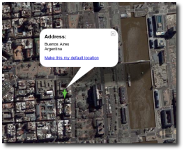
 Google Earth, the downloadable map application provided by the search giant, allows users to view maps and other satellite imagery captured directly from the satellites. Although the program was meant to help users analyze world maps, it seems like Google Earth is extremely useful in many domains, others than the one described by the search giant. The latest case reported concerns a revenue agency from Argentina that installed Google's application to discover undeclared property in the area.
"A provincial revenue agency down in Argentina is using Google Earth Pro to find tax dodgers. With this approach, the taxman for the Buenos Aires province detected 1184030 square feet of undeclared property. Google's Earth Pro subscription allows the agency to import site plans and property lists, and export high-quality images. It also allows to transfer "up to 2,500 locations by address or geospatial coordinates from a spreadsheet" and includes measurement tools -square feet, mile, acreage, and the like- by point and clicking on the screen," The Inquirer reported.
Let's have a quick sight in the past and over the goals of using Google Earth. The first case that attracted mass-media's interest was reported in Basra where the terrorists were using the downloadable application to organize attacks against the UK troops in the area. At that time, Google replaced the images with older ones captured before the departure of the army in the zone, trying to block malicious eyes from accessing certain photos.
Another interesting case was reported in multiple locations from every corner of the world where several researchers used Google Earth to monitor the volcanoes activity in specific areas. Because the application provides detailed imagery captured from the satellites and updated periodically, it helped engineers to monitor every change recorded near the volcanoes.