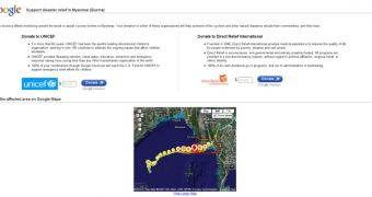
By now, most of you have noticed the "Support victims" link featured on the Google home page. As we also informed you, Google and other organizations have put a considerable effort in trying to help the victims of Cyclone Nargis. The devastating cyclone, which hit the Myanmar capital last weekend, is said to have taken the lives of over 350 persons, as first estimations indicate.
Besides the featured link, Google also helps its users better understand the consequences of last weekend's disaster, with the help of Google Earth. Users who have this software application can download a KLM data file, allowing them to preview satellite images of Nargis. They can also see images taken before and after the cyclone hit the coast of Myanmar. A recent update on Google Earth now displays more visualizations of Nargis and the surrounding affected areas.
As users can see in the provided imagery, the entire lower part of Burma has been seriously affected by the devastating weather phenomenon. The update includes images of Nargis's path, weather data and even satellite photos captured after the flood occurred. Besides the photos offered by Google, other organizations have also provided images showing the aftermath of the storm. In so doing, Google aims to offer people the means of realizing the consequences of the Nargis over the state of Burma.
Anyone who wants to help the victims in Myanmar can do so through the various charity actions, or by donating money with the help of Google's "Support disaster relief in Myanmar" webpage. This webpage now features a built-in Google map displaying satellite imagery from the affected areas. You won't need Google Earth to view these updated images. Still, the updated imagery is only for the surrounding areas of the affected Myanmar. We will continue to keep you updated with news about Google's support of Myanmar victims.

 14 DAY TRIAL //