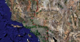
Google Earth, the downloadable application able to display maps and other imagery with the entire world straight from the desktop, receives another important update meant to consolidate the leader position of the application. After the parent company Google signed a deal with Trimble Outdoors, the search giant announced that the downloadable application will provide GPS content to display routes, points of interests and directions. At this time, a similar feature is already implemented in Google Maps, an online version of Earth that offers almost the same functions as the downloadable program.
"You can access lots of multimedia info on fitness and outdoor adventures, including routes, points of interest, pictures, video segments and even audio clips. Essentially, anytime, anywhere you can launch Google Earth, you can view hundreds of hikes that have already been logged and completed, and view personalized web content. Then, through the convergence of Trimble Outdoors' technology and Google Earth, you can click one button, and the exact trail route is exported to your GPS-enabled phone," Larry Fox, Business Development, Trimble Outdoors, sustained on the official blog of Google.
Recently, Google Earth caused new trouble for the search giant after the company was criticized for removing detailed pictures with Hurricane Katrina. According to the reports, Google removed the photos captured after the hurricane attacked the city, refusing to show damaged houses and Katrina's victims. The search giant replaces the pictures with older ones, captured before the hurricane. The company's officials sustained Google didn't remove the photos immediately, leaving them online to allow the authorities to rescue the victims. Google published all the pictures on a separate page and included all of them into a Google Earth file.

 14 DAY TRIAL //