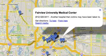
The user generated content displayed on Google Maps is more than useful these days when the authorities are struggling to discover the victims of the Minnesota bridge that collapsed some days ago. As you probably know, the tragedy took place at a rush hour so it's very important to join all the forces and give your support for rescuing the victims of the accident. That's why the users of Google's mapping tools created their own maps able to show traffic information as well as road closures and detours. Also, the Mountain View company modified the driving directions to avoid the damaged area and to provide the best alternatives for the local drivers.
"We have updated our driving directions to avoid the I-35W Bridge and to take into account other local road closures that have been enacted to help the flow of traffic. Our driving directions will now recommend the best alternative driving route in the face of these closures," Jess Lee, Google Maps product manager, wrote today.
This is not the first time when the search giant gives its support to help the authorities fight against a tragedy. Remember the Katrina hurricane? At that time, the Mountain View company created a special collection of Google Earth photos that showed the details of the damaged New Orleans. After some days of availability, Google removed the imagery and published it on a separate page in order to allow the interested users to install it and analyze the effects of the hurricane.
This decision made the local authorities to accuse the search giant of censorshipping the truth as Google Earth showed only older images captured before the assault of the hurricane over the city. However, the Mountain View company pointed the critics to the separate collection of photos and reminded them that Google did all it could to support the authorities.

 14 DAY TRIAL //