14 DAY TRIAL //
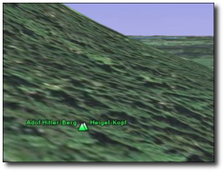
 Google Earth is brought again in the spotlights because the application provided by the search giant displays some Hitler details that are regarded as an incorrect information. It seems like Google Earth entitles a small town from Germany as Mount Hitler located at 1205 meters elevation. Although the mayor of the town contacted Google one year ago to remove the location or change the name, the Mount Hitler is still available to all Google Earth users.
"The mayor of a small town in Germany is asking Google to correct the name of a geographic feature called "Mount Hitler" in Google Earth, Reuters reports. The mountain gained its Nazi appellation during the Third Reich, but that name was changed after World War II. Google Earth users currently see both the old and new names. "We've been telling Google for years that they should take it down immediately," Wiedemann told Reuters. "It's misleading as it was only called that for a few years," Google Watch reported.
This is not the first time when Google Earth causes headaches for the company because of the content it provides. Some time ago, it was reported that terrorists were using Google Earth to organize attacks against the UK troops located in Basra. To fix the problem, the search giant replaced certain images with older ones captured before the departure of the army in the area. It was also reported that Google's product displayed some sensitive locations from Korea that presented secret areas or military forces. This time, Google avoided to replace the pictures but made them blurry to make the photos unavailable for the Google Earth users.
If you want to download Google Earth, you can find it on Softpedia using this link.