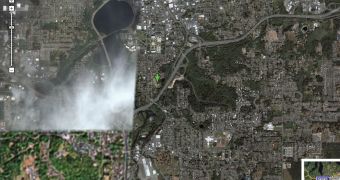
Following the recent imagery updates from Google Earth, the Mountain View company censored a major part of Washington in a move meant to hide sensitive locations from the public eyes. Although the search giant didn't announce it, some parts of Washington are not accessible since they were made blurry just like several other locations from Google Earth and Maps. According to the Washington Post, the Mountain View firm had two options concerning the latest imagery update: to keep the old photos that showed a limited amount of details or replace them with newer pictures that are censoring several Washington areas.
"The compromise? Google chose the new maps for most of the city but spliced in the older, fuzzier ones for about one-sixth of the District to include an unblocked view of the president's home and the Capitol," the Washington Post wrote.
In the past, Google had similar problems with Google Earth when the terrorists were using the downloadable mapping tool to organize attacks in multiple countries. The first case was reported in UK where the terrorists turned to Google Earth to attack the army located in Basra. Recently, it was reported that terrorists used the search giant's mapping tool to assault the JFK International Airport. In both cases, the parent company decided to replace the photos with older ones captured in the past.
"But the area in the older images also includes most of Ward 2: the Mall, the State Department, George Washington University, Union Station and several neighborhoods, including Dupont Circle, Shaw and Chinatown. That means the convention center that was demolished in 2004 appears intact and the National World War II Memorial that was completed in 2004 appears under construction," the same publication reported.
If you want to download the latest version of Google Earth, you can take it straight from Softpedia.

 14 DAY TRIAL //