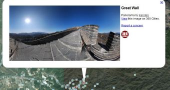
Panoramic photos are becoming increasingly popular, if only because it's a way of doing something a bit more original now that DSLRs are pretty affordable and point-and-shoot cameras are feature-packed. And now, you can showcase your 360 degree panorama photos in Google Earth.
"Today, the Google Earth photo viewing experience just got better with the addition of panoramic images," Wei Luo, Senior Geo Data Strategist at Google, wrote.
"People using Google Earth will find a new 'Photos' layer that includes not only the existing 2D photos from the Panoramio community, but also panoramic photos from around the world contributed by users of 360cities.net," he announced.
The panoramic photos come from 360 Cities, a community for showcasing 360 degree photos. These photos will be marked by red squares in Google Earth, as opposed to blue ones from Panoramio.
Clicking on the square will bring up an info bubble with a preview of the photo and info about its author. You can then view full image by clicking on it. You can 'navigate' inside the photo and move about to see the view from all the angles.
The images are now live in Google Earth for everyone. You can add your own photos by signing up and submitting them to 360 Cities.
"360 Cities has moved from the 'Gallery' layer in Google Earth to the new 'Photos' layer. This layer is new, and contains images by both Panoramio and 360 Cities. It is also switched on by default, which means that our images will be available to a larger audience than before!," 360 Cities announced on its blog.
Google has been adding more content sources to Earth. Recently, it added space user photos from Slooh. Regular, geo-tagged, images have been available in Earth from Panoramio, the Google-owned photo sharing service.

 14 DAY TRIAL //