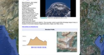
Google has made several updates to a couple of layers in Google Earth. The Mountains layer in Earth now has a lot more information on many mountain peaks around the world, including more details in the information window, Panoramio photos and even KML tours. The Water Bodies layer now contains hundreds of thousands of new labels, Google also announced.
"Mountains have long been catalysts for inspiring artists and challenging the human spirit," Cris Castello, GIS Data Engineer at Google, wrote.
"Today, we're adding a host of new features to the 'Mountains' layer in Google Earth, to more easily appreciate their elegance and beauty. To see the layer, make sure 'Mountains' is checked in the left layers panel of Google Earth," he announced.
Most peaks now have a green label, signaling them even from high zoom levels. Clicking on it will pop out an info bubble which contains several data sources.
There is a description of the mountain along with photos from Panoramio, the geo-location focused photo sharing service. There is a link to get more info and you can also slide through several photos of the peak.
There is also an Elevation Profile section which displays a cross-section of the mountain from various directions, you can switch between S-N, W-E, NW-SE and SW-NE. Finally, there is also a shaded relief image of the mountain in the information pop-up.
An interesting addition are the tours that Google has created for each mountain. There is a link to view a tour of the peaks which downloads a KML file. 'Playing' it will begin a tour which circles the peak to get a good view from all the angles.
The Water Bodies label, found under the Mountains one in the "Borders and Labels > Labels" section, now has data for hundreds of thousands of water bodies from around the world. Rivers have not been added yet, but anything from seas, to bays, lakes, and reservoirs is available.

 14 DAY TRIAL //