 14 DAY TRIAL //
 Last week, many publications reported that Google Earth, a downloadable application provided by the search giant that allows you to view satellite maps was used by terrorists to attack UK troops located in Basra. Army specialists found multiple documents from terrorist groups containing several satellite images that were captured with Google Earth, displaying army bases or other vulnerable locations. Imagine that the program can be very useful because it displays real time images so any UK army action can be monitored and reported with ease. Google's representatives sustained that the company discussed with army's officials but they cannot publish the results of the meeting.
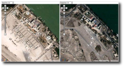
Although the company refused to offer any consequence of the discussion, many internet users reported that Google replaced some images that displayed UK army or other important images. It seems like the new images included in Google Earth were made in 2002, a calm period before the war that involved the UK army.
"Currently, images in Google Earth of Basra are from 2002, months before war. Up until a recent update, the images were likely from late 2004 and/or 2005. You can tell by engaging in a little forensic mapping, using Google Earth's built-in "Digital Globe Coverage" layer (which provides dates for its imagery), the Google Tile Comparison tool (which shows you what previous datasets looked like) and also with a little help from Google Earth Community," Ogle Earth said.
"A Google spokesman said the information could be used for "good and bad" and was available to the public in many forms. "Of course we are always ready to listen to governments' requests," he said. "We have opened channels with the military in Iraq but we are not prepared to discuss what we have discussed with them. But we do listen and we are sensitive to requests," the same source said.