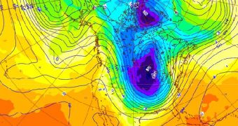
Scientists with the European Center for Medium-Range Weather Forecasts (ECMWF) have recently released this new visualization of the Polar Vortex roaming freely over the central United States. This atmospheric formation is responsible for the extremely-cold temperatures recorded recently.
Usually, this vortex lies atop the North Pole, but some atmospheric factors can throw it off-balance and send it to other locations. This is precisely what happened this year, and scientists believe the process may have been caused by global warming, Science Blogs reports.
This is based on data collected on the Polar Vortex over the past few years, which show a trend for the atmospheric formation to depart the North Pole. This leads to the weird scenario we see today, where temperatures in the Arctic are higher than those in the middle of the continental United States.
The Polar Vortex is an atmospheric cold air circulation pattern that contains the frigid air over the Arctic. Usually, it stays above the North Pole, and displays only minor deviations. However, over the past decade or so, it has begun moving away from its standard location more and more every year.

 14 DAY TRIAL //