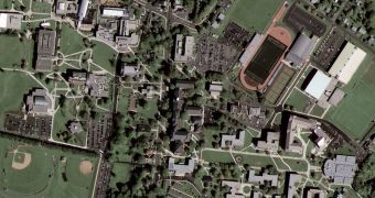
Since its launch, on September 6th this year, Google's top-notch satellite has constantly been fine-tuned in order to get even more accurate results. The ultra-high definition images that it is able to provide make GeoEye-1 the world's best commercial satellite.
The state-of-the-art device's first public attempt consisted of a top-down accurate view of Pennsylvania's Kutztown University (showed in the adjacent picture). But even if the satellite is provided with a large Google sticker, the Mountain View company is actually only its second main customer, after the National Geospatial-Intelligence Agency (NGA), a United States governmental agency which analyzes the images it sends back for national security purposes. NGA contributed with half of the project's development expenses for this privilege, which translates into $251 million. It is the only organization that can actually use the full power of GeoEye-1's 43 centimeter maximal resolution, as this is prohibited by a governmental restriction for the second major partner, Google, which can only use imagery starting with 50-centimeter resolution. The satellite travels at a speed of 17.000 miles per hour (27.360 kilometers/hour), or 4.5 miles per second (7.25 kilometers/second), orbiting the Earth from an altitude of 423 miles (681 km).
In an interview for Wired magazine, GeoEye's vice president of communications and marketing, Mark Brender, explained, “This is the opposite of a spy satellite. Spies don't put info on the Internet and sell imagery. We're an Earth-imaging satellite, and we can sell our imagery to customers around the world who have a need to map and measure and monitor things on the ground. We're commercializing a technology that was once only in the hands of the governments. Just like the internet, just like GPS, just like telecom – all invented by the government. And now we are on the front end of the spear that is commercializing this technology.”
Google's next satellite, GeoEye-2, will be able to provide 25-centimeter resolution images, but Google will still be restricted to their 50-centimeter limitations. The launch of GeoEye-2 is set for sometime in 2011 or 2012.

 14 DAY TRIAL //