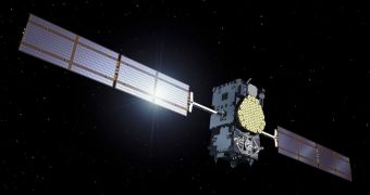
With the first two Galileo In-Orbit Verification (IOV) satellites already in orbit, the European Space Agency (ESA) is currently pondering whether or not the spacecraft could also be used to manage distress calls and other types of emergency.
Galileo is being developed primarily as a satellite navigation and global positioning system. When complete, it will feature nearly three dozen components, spread out in strategically-placed orbital points, to ensure maximum coverage.
ESA officials say that the assets could enable additional uses. For example, they believe that the constellation would handle emergency beacon location processes admirably. Pinpointing the exact source of a distress call may mean the difference between life and death in an emergency.
For this reason, the organization is planning to use the next 24 months to test a major expansion of the international Cospas–Sarsat humanitarian system, an asset that has been in place for the past 30 years.
It's made up of a Russian component called Cospas (Space System for the Search of Vessels in Distress) and an international one, called Sarsat (Search and Rescue Satellite-Aided Tracking). The system has proven its efficiency many times over, helping to rescue more than 24,000 lives.
“The service’s slogan is ‘taking the search out of search and rescue’,” ESA engineer Igor Stojkovic says. The Cospas-Sarsat system works by identifying the source of activated radio beacons, and then relaying the relevant instructions to local authorities closest to the emergency site.
But these capabilities can be extended by using Galileo, experts agreed at a conference held on February 27, at the ESA ESTEC technical center, in Noordwijk, the Netherlands. Officials from 21 countries were present at the ceremony. Stojkovic participated as well.
“We’ve finalized plans for a worldwide test campaign as we extend existing Cospas–Sarsat capabilities to international navigation satellites,” he reports.
“Search and rescue packages are also being carried by US GPS and Russian Glonass satellites, though with most of Europe’s Galileo constellation being deployed within the next few years, Galileo is leading the way,” Stojkovic goes on to say.
Sarsat is the result of a collaboration between the United States, the Russian Federation, France and Canada. Since the late 1990, the Cospas-Sarsat constellation also has geostationary support, with some of its components placed as high as 36,000 kilometers above the planet.
“Now Cospas–Sarsat is moving to using navigation satellites in medium orbits. Navigation satellite constellations have been carefully designed for worldwide coverage, and can perform a combination of time- and frequency-based ranging for single-burst distress call positioning,” Stojkovic concludes.

 14 DAY TRIAL //