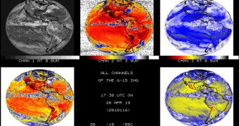
Experts at NASA and the US National Oceanic and Atmospheric Administration (NOAA) announce that their newest orbital satellite has finally opened its infrared “eyes” a couple of days ago. The group says that the Geostationary Operational Environmental Satellite (GOES-15) took the first images of our planet in these wavelengths from its vantage point, some 22,236 miles above the surface, on April 26.
The infrared equipment on GOES-15 is of tremendous practical importance, especially to meteorologists and weather forecasters. Observing the planet in these wavelengths enables these experts to gain more data on temperatures on the ground, in the sea and in the air, as well as to derive various other data. For example, they can calculate wind, temperature and moisture profiles for the atmosphere, and can observe how smoke plumes – such as those from volcanic eruptions – migrate across the surface of the planet. The IR instruments can also be used to monitor wildfires, experts add.
“This (image) marks the final stage of the critical events for the spacecraft and indicates that the visible and infrared spacecraft imaging instruments are performing as expected. We’re looking forward to more imagery as we finish up post-launch testing,” explains the NASA GOES deputy project manager, Andre Dress. The expert is based at the space agency's Goddard Space Flight Center (GSFC), in Greenbelt, Maryland. The new picture was snapped using the multi-channel GOES Imager instrument, Space Fellowship reports.
Another instrument that can produce advanced-quality infrared data is the GOES Sounder. Using datasets this payload collects, mathematicians can apply analysis technique to determine surface and cloud-top temperatures, as well as ozone distribution, temperature and moisture profile across the planet's atmosphere. The first infrared information came from GOES less than three weeks after the satellite relayed its first visible-light images of Earth, on April 6. The space craft was launched on March 4 this year, from the Cape Canaveral Air Force Station (CCAFS) Space Launch Complex 37, in Florida.
NOAA and NASA began verifications of GOES-15's systems on March 24. The procedures will last for about 150 days, after which time NASA will hand over operational control of the spacecraft to NOAA.

 14 DAY TRIAL //