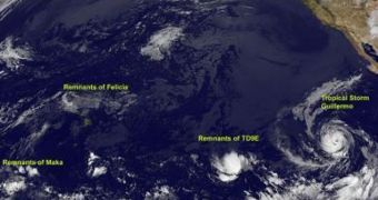
The US National Oceanic and Atmospheric Administration's (NOAA) satellite, GOES-11, launched in 2000, has recently beamed back images detailing fizzling tropical cyclone formation in the eastern parts of the Pacific Ocean, the NASA Goddard Space Flight Center reports. The data collected from the eye-in-the-sky are constantly being posted by graphics experts at the center, and meteorologists around the world are keeping an eye on the details. This week showed an increased in activity, and climate experts are tracking a few storms that could become dangerous.
This week, GOES-11 observed the remnants of Maka and of the Tropical Depression 9E, as well as a fizzled Felicia, and a new tropical storm named Guillermo. The good news is that Maka and Felicia appear to be dissipating, after the latter failed to reach Hawaii, where it could have turned dangerous. On the other hand, the former is about 1,400 miles west-southwest of Kauai. Its remnant clouds and showers are heading west, and experts believe that there is little chance they will be able to pull together, and form a dangerous atmospheric front again.
In the other eastern half of the ocean, the Tropical Depression 9E (TD9E) seems to be dwindling in intensity, although experts haven't ruled out the possibility that it may come back to life later on. The formation is spinning at a slow speed of about 30 miles per hour, and moving ahead at just 9mph. That's why they are constantly keeping an eye on the formation, so as to prevent any potential negative surprises. The East Pacific is also the area where the new storm Guillermo formed, from the Tropical Depression 10E (TD10E), experts announce.
Scientists from the National Hurricane Center (NHC) announced that, though TD9E is still some 1,750 miles west-southwest of the southern tip of Baja, California, it may still gather sufficient strength to form a tropical depression. Shower and thunderstorm activity in the region are increasing, which means that the environment is suitable for any forming storms. Meteorologists keeping an eye on the situation are amazed at the fact that hurricanes are already so intense, despite the fact that the official peak of the season doesn't start for another month.

 14 DAY TRIAL //