14 DAY TRIAL //
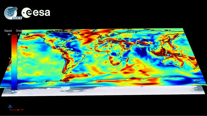
 The European Space Agency's (ESA) Gravity Field and Steady-State Ocean Circulation Explorer (GOCE) satellite has finally begun transmitting high-quality data from its peculiar, low orbit around the planet. Its ultra-sensitive instruments analyze subtle variations in the Earth's gravitational pull over various regions of the globe, and the mission's main objective is to produce the first full map of these variations. Its secondary objective is to create the first image of the planet's spheroid, a feature that does not necessarily represent its actual shape, but that is of tremendous use for scientists.
Having recently completed its calibration and instrument-tuning stages, the observatory is now ready to start collecting the most precise gravitational measurements of our planet. The craft is practically free-falling through the atmosphere, as it circles the globe, and engineers have outfitted it with a highly precise and very smoothly running ion thruster. The motor is able to accelerate the craft in such a manner that its instruments are not affected.
Jolts are to be avoided for such a mission, the experts say, if a clear picture of the Earth's geoid is to result. Such a map would essentially paint a portrait of the planet as it would look if it were covered by a smooth ocean and had no altitude variations. Measurements will be conducted in two six-month stages, over each of which the instruments will function non-stop. It took more than six months after launch for ESA engineers to finally commission the observatory, Space Fellowship reports.
“You wouldn’t want to place a satellite like GOCE at the measurement altitude from day one. We needed time to check the satellite without running the risk of decaying below the point where the ion propulsion could not compensate for the air drag. Therefore, at launch we injected GOCE into an initial orbit about 25 km above the measurement altitude,” the ESA GOCE System Manager, Michael Fehringer, explains.
“After commissioning, we brought it to its current altitude of 255 km, which we reached on 13 September. The ion propulsion started immediately and now we are in drag-free mode, ready for operation,” he adds. “The completion of the commissioning and first in-flight calibration marks an important milestone for the mission. We are now entering science operations and are looking forward to receiving and processing excellent three-dimensional information on the structure of Earth’s gravity field,” the ESA GOCE Mission Manager, Rune Floberghagen, concludes.