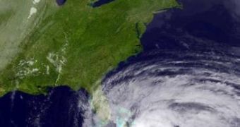
The US East Coast is now facing a tremendous threat: a so-called “Frankenstorm,” which is basically the result of Hurricane Sandy's coming together with a winter storm and blasts of extremely cold wind originating in the Arctic regions.
Specialists fear that, once these three natural phenomena combine, the resulting storm will have devastating effects, given the fact that, according to their estimates, there are 90% chances that it will end up hitting the US East Coast as early as next week.
The US National Oceanic and Atmospheric Administration warns that, although there are some uncertainties with respect to the Frankenstorm's behavior, communities on the East Coast must get ready to face both heavy rain and very strong winds.
Having already hit Jamaica, parts of Cuba and the Bahamas, hurricane Sandy made two human victims, sources report.
Therefore, it is quite likely that, once it combines with said winter storm and the Arctic cold wind, the threats posed by it will be even greater.
Besides human losses, it is expected that the Frankenstorm will destroy thousands of homes and that the total damages will amount to roughly $1 billion (€0.77 billion), Earth Sky says.
This is because this storm has the potential to cause power outages, massive inland floods, heavy snow and significant wind damage.
Some say that these power outages could last for almost an entire week, which is why American citizens are asked to be prepared. Other sources explain that the damages caused by the Frankenstorm are to be augmented by the fact that tides will be at their highest.
Apparently, the US National Hurricane Center believes that the storm will first hit New England this coming Monday night at the earliest, and during Tuesday morning at the latest.
The US National Oceanic and Atmospheric Administration commented on this unusual storm as follows: “The lion's share of guidance indicated that the circulation associated with hurricane Sandy will pass close enough to the amplifying polar trough over the eastern United States to become incorporated into a hybrid vortex over the mid Atlantic and northeast next Tuesday.”
Furthermore, “The high degree of blocking from eastern north America across the entire Atlantic basin is expected to allow this unusual merger to take place, and once the combined gyre materializes, it should settle back toward the interior northeast through Halloween, inviting perhaps a ghoulish nickname for the cyclone along the lines of “Frankenstorm,” an illusion to Mary Shelley's gothic creature of synthesized elements.”

 14 DAY TRIAL //