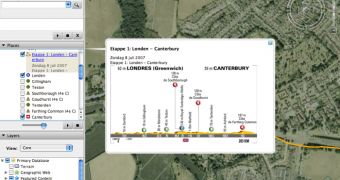
Google Earth is updated again by the community of users after an exciting imagery update was rolled out on the Internet. The recently released KMZ file contains the Tour de France routes as well as valuable information and details about the entire competition. According to the Google Earth Blog, the file was created by a user called Timetxu who also uploaded it on a Dutch forum.
"With GE's 3D terrain, you can tilt your view and truly get a feeling of how challenging this race really is - even if you have never been to see it in person. An important difference this year for Google Earth viewers is that the imagery for the French Alps has been greatly improved now that Google Earth includes medium resolution 2.5 meter resolution imagery from Spot Image," it is mentioned in the Google Earth Blog post.
As you can see if you decide to analyze the imagery, it is not entirely based on high-resolution pictures as some of them were updated a long time ago. Here's what you must do if you want to use the KMZ file with your Google Earth program: first of all, you must download the file using this link. Open Google Earth, click on File and select the downloaded pack of images. After the import process is completed, have a look at the Temporary Places box and click on Tour de France. Select any of the routes and admire the panoramas.
Google Earth is continuously kept in the spotlights and, even if the parent company Google doesn't update it, the community of users is making the application better. This new pack of images is very relevant when it comes to the power of the users because the Google Earth content is enhanced even without the contribution of the Mountain View company.

 14 DAY TRIAL //