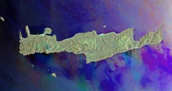
This image collected by the European Space Agency's (ESA) Envisat spacecraft is focused on the history-rich Greek island of Crete, which is located at the intersection between the Aegean and Libyan Seas. Both of them are located in the eastern Mediterranean Sea.
The photo also includes a part of the Cyclades island group, which features the islands of Milos, Ios, Anafi and Santorini. Of these, two are backward-C-shaped and volcanic in appearance – Milos and Santorini. The latter was once a massive volcano, which erupted and blew off most of the mountain above.
Envisat needed three radar passes to collect the necessary data to compile this view. The passes were made on December 11, 2010, and January 10 and March 11, 2011. The photo also shows discernible differences in color, which reflect how the sea looked each time the satellite zoomed over.

 14 DAY TRIAL //