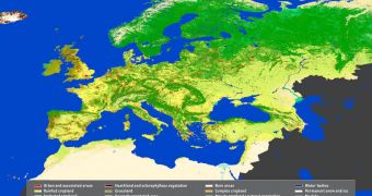
The European Union is expanding, it's population growing, and it's soils and lands are facing an increased pressure from all direction. Officials need to be in top of the situation at all times, and now they have a new satellite map to aid them.
Officials with the European Space Agency (ESA) said that the map was produced with the aid of the MERIS instrument aboard the organization's Envisat satellite.
The investigation was conducted as a part of the pan-European GlobCorine land cover and use map project, and it was since published online. The tool provides a clear view of how land is used in Europe, as you can clearly see in the attached image.
One of the things that surprised mission controllers was that they finished the entire map while using data collected exclusively between January 1 and 31 December 2009. The compiling then lasted only 9 months, as opposed to years.
Environmental agencies in Europe, which are the main beneficiaries of these maps, will be able to benefit from regularly-updated versions, as the GlobCorine service is automated.
This means that it can both generate and update the maps, which are produced at a resolution of 300 meters. The first fully-processed map produced by MERIS was delivered to the European Environmental Agency (EEA) in October.
“The novelty of this map is that we can finally have relevant, timely global land cover information compatible with the time series of European Corine land cover data for decision-making,” explained expert Chris Steenmans.
The official holds an appointment as the head of the EEA Shared Environmental Information System program. He made the announcement in Italy last week, at a meeting held at the ESA Earth observation Center (ESRIN)
“If you want to bring the environment into the context of economic and social development, then the speed of environmental information delivery needs to keep pace with economists and decision-makers for sustainable development,” Steenmans said,
“This means we can’t continue what we have done in the past, which was to report on land use changes using three or sometimes five-year-old data,” he went on to say.
“Instead, we have to provide up-to-date figures that will help us to monitor sustainability of our ecosystem services,” he added.
This type of tools is very important as Europe is engaging more and more on the path to reducing greenhouse gas emissions and regulating pollution. The maps will also be used by climate modelers to gain new insight into how global warming is changing the planet.

 14 DAY TRIAL //