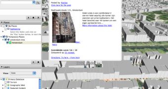
Amsterdam is one of the first cities that became 100 percent available as a Google Earth 3D city. The parent company Google managed to create all the buildings in 3D format, designing numerous gray colored shapes for Amsterdam. As Google Earth Blog reported, the buildings are created in 2.5D view, just like the other buildings included some time ago for various major cities.
"The building models are those simple, gray colored, type of models that give you an idea of the size and dimensions of buildings. Just like the 3D buildings that Google Earth first released almost two years ago for 35 US cities, and then later for most of Japan. These buildings will undoubtedly be used for the 2.5D views shown for Google Maps to provide an feel for buildings in major cities," the publication reported.
All you need to do to view the 3D Amsterdam is to place this file hosted by Google Earth Blog into the downloadable application. To do this, you need to open Google Earth, go to File and select Open. Choose the downloaded file and enjoy the Amsterdam 3D view. The new file should appear in the Temporary Places box displayed on the left part of the screen.
As you might know, Google recently launched a new version of Google Earth, the 4.1 beta release bringing a lot of new features for the downloadable application. Besides the tips displayed at the run of the program, the parent company added interoperability with Google Maps, allowing users to view a certain location straight in the window of their browser. The search giant also improved Google Maps with a lot of new imagery showing streets and buildings from numerous countries all over the world. If you want to download Google Earth, you can take it straight from Softpedia using this link.

 14 DAY TRIAL //