The European Space Agency's (ESA) Gravity Field and Steady-State Ocean Circulation Explorer (GOCE) satellite may have ended its mission, but the vast volume of data it collected over the years remained. Now, experts are using it to reveal how earthquakes affect the planetary crust.
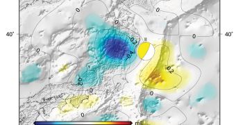
Using GOCE information, ESA scientists were recently able to determine that the 2011 earthquake which struck off the coasts of Japan with a magnitude of 9.0 on the Richter scale left behind a mark in Earth's gravitational pull at that location.
This is another example of how data collected by the world's most beautiful satellite are used for studies well beyond the mission's original scope. The purpose of the GOCE spacecraft was to create the most accurate Earth gravity maps ever developed.
When looking at GOCE data for March 11, 2011, experts noticed a significant decrease in Earth's gravitational pull off Honshu Island, in the Japan archipelago. Earthquakes have been known to deform the planetary crust and shift Earth's orbit, but their effects on local gravity are just now being discovered and analyzed.
Due to its sensitivity, the ESA mission was able to map tiny variations in gravity that occur all over our planet. For example, the area occupied by the Himalaya mountain chain has a higher gravitational pull than the Atlantic Ocean basin, which features a thinner crust, and therefore less matter.
“There are a number of reasons why values of gravity differ, but one is a consequence of material inside Earth being inhomogeneous and unevenly distributed,” officials at ESA say in a new statement.
“Since earthquakes shift around rock and other material tens of [kilometers] below the surface, they also cause small changes in the local gravity,” the research group adds. The 2011 tremor occurred under the ocean, so it also displaced a large volume of water. GOCE was able to see the tiny gravitational perturbation this caused in the area.
The new investigation of GOCE data was carried out by researchers with the German Geodetic Research Institute (DGFI) and the Delft University of Technology, in the Netherlands. They say that GOCE confirmed earlier measurements provided by the Grace satellite.
“Thus, we see that GOCE gravity gradients complement other types of data such as seismic, GPS and GRACE satellite gravimetry. We are now working in an interdisciplinary team to combine GOCE data with other information to obtain a better picture of the actual rupture in the gravity field than is currently available,” DGFI expert Martin Fuchs concludes.

 14 DAY TRIAL //