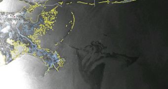
Scientists at the European Space Agency have just released a new set of images that show the extent of the oil spill in the Gulf of Mexico. On April 20, the Deepwater Horizon oil rig exploded and then sank into the waters there two days later. Since then, thousands of barrels of crude oil have been spilling into the Gulf each day, and the ensuing oil slick now threatens Louisiana coastlines, delicate natural reserves, as well as beaches belonging to several cities. ESA satellite Envisat has been keeping an eye on the evolution of the oil stain, officials at the space agency say.
Over this weekend, changing winds hampered clean-up efforts, just like they did last weekend. Numerous vessels belonging to BP, the oil company that operated the semi-submersible platform, and state and federal authorities are attempting to deploy various blocks that could stop the oil slick from advancing towards the coast. However, rough seas and unforgiving winds are rendering their best efforts useless. The oil has now reached an area immediately adjacent to the Mississippi Delta National Wildlife Refuge, as seen in the new Envisat image.
The white dots and lines that also appear in the photograph are in fact ships attempting to limit the scale of the devastation. But things do not look very promising, as US President Barack Obama said himself that the disaster might be unprecedented in scale. The American efforts are being aided from several sources, including ESA, which provides Envisat data to relevant US authorities under the provisions of the International Charter Space and Major Disasters. The US Coast Guard delegated the US Geological Survey (USGS) to make an official request for the fast-response data from ESA.
As such, Envisat images of the Gulf of Mexico oil slick are available to the USCG two hours after ESA mission controllers download them from the satellite. “Envisat acquired these images from its Advanced Synthetic Aperture Radar (ASAR) and Medium Resolution Imaging Spectrometer (MERIS) on 2 May 03:45 UTC (Saturday night local time) and on 2 May 16:10 UTC (Sunday morning local time), respectively. Radar is especially suited for detecting oil spills because it works day and night, can see through clouds (unlike optical sensors) and is particularly sensitive to the smoother water surface caused by the oil,” ESA experts write in a press release.
“The next ASAR and MERIS images of the oil spill are scheduled for 5 May, with the images being made available about two hours later. Envisat images are being provided to US authorities immediately after they are acquired through the International Charter Space and Major Disasters. On 22 April the US Geological Survey, on behalf of the US Coast Guard, requested the Charter to provide rapid access to radar and optical satellite imagery of the oil slick. Since then, Envisat MERIS and ASAR data have been provided in near-real time and have been used by the US National Oceanic and Atmospheric Administration [NOAA],” they add.

 14 DAY TRIAL //