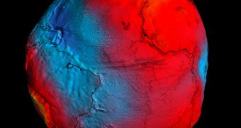
Earlier today, March 31, the Technische Universität München (TUM) in Munich, Germany hosted the Fourth International GOCE User Workshop, which was organized by the European Space Agency(ESA). At the meeting, experts were presented with the first geoid model the satellite produced.
The Gravity Field and Steady-State Ocean Circulation Explorer (GOCE) is widely considered to be the most beautiful satellites ever constructed, and also one of the most advanced. As evidence, it only needed two years to complete its primary mission.
That was no easy task – the spacecraft had to analyze the most minute variations in Earth's gravitational pull, and then put together a map of these variations. It did so with extreme precision.
The data were put together in a geoid – a figure showing how the Earth's oceans would look like without tides and currents affecting their circulation. In other words, the geoid shows the world ocean, as it would look if its shape was modeled by gravity alone.
In less than 24 months, GOCE produced the most accurate model of the geoid ever created. The datasets the satellite put together were revealed to the public today at the TUM workshop.
The geoid will play a critical role in climate models. By using it as a reference frame, experts will be able to gain a deeper insight into processes such as ocean circulation, ice dynamics and rises in global sea levels, ESA experts explain in a statement.
“We see a continuous stream of excellent GOCE gradiometry data coming in. With each new two-month cycle, our GOCE gravity field model is getting better and better,” says professor Reiner Rummel, who is the former head of the TUM Institute for Astronomical and Physical Geodesy.
“Now the time has come to use GOCE data for science and applications. I am particularly excited about the first oceanographic results,” the expert explains further.
“They show that GOCE will give us dynamic topography and circulation patterns of the oceans with unprecedented quality and resolution. I am confident that these results will help improve our understanding of the dynamics of world oceans,” he adds.
At the Fourth International GOCE User Workshop, mission controllers handling the satellite will be briefing participants as to the state of the spacecraft, and that of the services and products it supplies.
GOCE data will also be used to improve tectonic plate interactions models, which would in turn help geologists gain a better understanding of how devastating earthquakes such as the one that devastated Japan on March 11 take place.
“This is a highly significant step for the mission. We now look forward to the coming months, when additional data will add to the accuracy of the GOCE geoid, further benefiting our data users,” adds the ESA GOCE mission manager, Rune Floberghagen.

 14 DAY TRIAL //