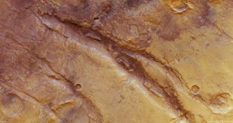
Officials at the European Space Agency (ESA) have just released a new series of images captured by the Mars Express orbiter. The datasets cover a system of deep fractures called Nili Fossae, which are located around a giant impact basin known as Isidis.
At this point, astronomers' best bet in explaining how the structures formed would be to assume that they appeared at the same time the neighboring basin did. Some of the fractures in the system reach a depth of over 500 meters (1,640 feet).
Without thinking of them as having formed at the same time as Isidis did, experts would have a really big problem in explaining why Nili Fossae appeared. The entire ensemble of cuts and creases is cataloged as a “graben” system, officials at the space agency explain.
Geologists define a graben as a depressed block of land bordered by parallel faults. The area that will go on to produce grabens are usually pushed down, and this leads to the creation of a valley of sorts.
Tectonic forces are oftentimes responsible for the creation of grabens, as they are in the habit of collapsing the rocks between two fault lines. As the land falls in on itself, a new valley is formed.
Nili Fossae is located around the northwestern edge of the Isidis impact basin, and the grabens it contains are oriented concentrically around the landscape feature's edges, planetary scientists add.
It could be that the fractures form as the area released the vast amounts of tectonic pressure it was subjected to after the object that formed Isidis impacted the Martian surface. As this happened, the newly-formed basin was flooded with basaltic lava, that strained the planetary crust.
“A strongly eroded impact crater is visible to the bottom right of the image. It measures about 12 km across and exhibits an ejecta blanket, usually formed by material thrown out during the impact. Two landslides have taken place to the west of the crater,” ESA experts say in a press release.
“A smaller crater, measuring only 3.5 km across, can be seen to the left of centre in the image and this one does not exhibit any ejecta blanket material. It has either been eroded or may have been buried,” the investigator goes on to say.
The reason why experts are so interested in learning more about this fracture system is the fact that atmospheric methane concentrations spike over this area, as seen by telescopes on Earth and in space.
If methane is indeed produced here in higher amounts than in other areas of the planet, then experts still have no plausible explanation for why that may be happening. Future investigations – or perhaps a direct mission to Mars – may help solve that mystery.
This may happen in 2016, when NASA and ESA plan to launch a joint mission called the ExoMars Trace Gas Orbiter. The instruments on this spacecraft will scrutinize Nili Fossae in the tiniest detail.

 14 DAY TRIAL //