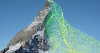
It's one thing to make a drone and have it circle a rock, and another matter to make a whole swarm of them and have them fly around a mountain for six hours straight, but that's what senseFly did.
SenseFly is a company that created a swarm of ebees drones. Said drones were ordered to map out the Matterhorn.
Matterhorn (German), Monte Cervino (Italian) or Mont Cervin (French) is a mountain in the Pennine Alps on the border between Switzerland and Italy, with a summit 4,478 meters (14,690 ft) high.
The drones took, in total, 2,000 high-resolution photographs of every nook and cranny.
The result was an astonishingly accurate 3D model, once a company called Pix4D got its hands on the photos and analyzed them, constructing the 3D model out of 300 million data points.
The model is said to be accurate to within about four inches, despite the drones not using surveyor’s tools to map the surface.

 14 DAY TRIAL //