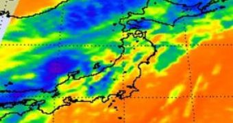
After blowing over the East China Sea towards the Korean Peninsula, NASA's Aqua Satellite captured images of the Tropical Storm Dianmu entering the Sea of Japan yesterday and predicted that today it would make landfall over north Honshu, Japan.
Dianmu started in early August and two days ago, the US Navy's Joint Typhoon Warning Center (JTWC) announced that it had reached winds of 100 km per hour with gusts up to 130 km per hour, and that it was at only 500 km south-southwest of Seoul.
Yesterday, the Atmospheric Infrared Sounder (AIRS) instrument on board NASA's Aqua satellite made an infrared image of the Dianmu tropical storm crossing briefly over South Korea and entering the Sea of Japan and showed movement tendency toward the North Western Pacific Ocean.
At 11 am with maximum sustained winds of 46 mph, it was located at 500 nautical miles west-southwest of Misawa, Japan and was moving east-northeast at almost 20 mph, generating 15-foot high waves in the Sea of Japan, e! Science News reports.
According to AIRS imagery, the strongest area of convection – the air that rises rapidly and forms thunderstorms that power a tropical storm – evolved from Dianmu's center toward an elongated system with most of the convection in the eastern part of the storm.
While advancing, Dianmu encounters increasing vertical wind shear and cooler sea surfaces and it begins its transition into a weaker extra-tropical storm.
The Moderate Resolution Imaging Spectroradiometer (MODIS) on NASA’s Aqua and Terra satellites captures images of storms, cyclones and hurricanes as the two satellites view the entire surface of the planet every 1 to 2 days.
This allows a better understanding of what is happening on the land, in the oceans and in the lower atmosphere and supports the development of global interactive Earth system models that can predict global change with precision.

 14 DAY TRIAL //