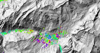
Officials at the European Space Agency (ESA) say that data from their flagship Earth-observing satellite, Envisat, are now being used to investigate landslides that occur in Switzerland. This is possible thanks to the advanced radar instrument on the spacecraft.
Scientific tools such as this one are capable of detecting land deformations with an accuracy level of just a couple of centimeters, which means that they are perfect for analyzing landslides, the effects of volcanic eruptions, the debris left behind by avalanches, and so on.
Envisat is especially well suited for conducting this type of investigations because it has been orbiting Earth since March 1, 2002. This means that it surveyed many regions of the world more than once.
This is absolutely essential for creating land deformation maps. The technique through which these datasets are obtained is called Differential Interferometric Synthetic Aperture Radar (DinSAR).
During its time in orbit, Envisat has compiled a massive library of data showing land elevations, among other things. By comparing images of the same location, taken over several years, DinSAR can determine how the land changes over time.
“The use of Envisat data for landslide monitoring had a difficult start. In the early days of the mission, SAR data were acquired in many different modes so that no consistent archives were built,” says the CEO of Gamma Remote Sensing, Urs Wegmüller.
“When the satellite was systematically programmed to gather dedicated data over the Swiss Alps in the summer, this significantly improved the situation so that we have now very good archives available,” adds the expert.
His company is providing various Swiss cantons with yearly regional hazard maps that are almost exclusively based on Envisat data. Thus far, these datasets turned out to be very useful indeed.
Radar satellites usually fly at altitudes of around 800 kilometers (498 miles), which provide the best vantage point for this type of studies.
ESA plans to get more involved in this type of study, starting with the launch of the Sentinel-1 satellite, which is currently scheduled to occur in 2014. All subsequent spacecraft in this constellation will follow suit, officials at the agency say.

 14 DAY TRIAL //