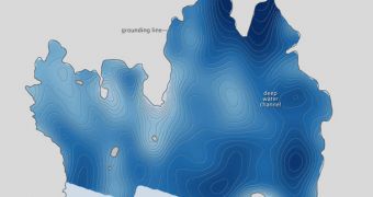
A little more than a year ago, a group of investigators carrying out a series of research flights above Antarctica discovered a hidden feature below the surface of Pine Island Glacier, in the form of a deepwater channel, that brought warmer water under the ice, heating it from beneath.
This particular glacier is in fact a floating ice shelf, so one of its role is to ensure that the large, ground-based ice sheets behind it remain land-locked, and not make their way into the ocean.
When sea-based ice, the global sea level does not rise by important values, But this changes when ground-based ices makes its way into the water. This type of ice can raise sea levels by several meters globally, bringing about floods and devastation in seaside metropolises.
Greenland and the Antarctic are the largest accumulations of ground-based ices in the world. In the past, a large part of the territory now covered by the United States and Canada was also covered in ice.
When that ice shelf made its way into the North Atlantic Ocean, it stopped the oceanic current circulation, which fuels Europe with warm air, and plunged the Old Continent into an Ice Age that saw ices reach as far south as the Mediterranean Sea.
Climate scientists are now fully aware of the importance Antarctica and Greenland have, and this is why they are monitoring them. The October 2009 studies were a part of that effort, and they were conducted by the American space agency as part of its IceBridge mission.
When the mapping instruments analyzed the water depth and seafloor topography underneath Pine Island Glacier, experts discovered a deepwater, warm water channel underneath the ice shelf.
The existence of such a feature is extremely dangerous, because it represents a possible pathway for increasingly warm water to make its way directly underneath the ice mass. The attached image shows the deepest regions underneath it in navy blue.
“It’s not the first time scientists have seen below the ice shelf. Earlier in 2009, the United Kingdom’s National Oceanography Center maneuvered an autonomous underwater vehicle below the shelf for a close-up look,” NASA says in a statement.
“But the robot encountered one of the high underwater ridges (seen in the topographic map above) and researchers assumed that the ridge extended the width of the shelf,” the press release adds.
With the new discovery, the currently-unexplained phenomena affecting the West Antarctic Ice Sheet might finally begin to make more sense, investigators believe.

 14 DAY TRIAL //