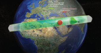
Since launching massive surveillance and intelligence satellites is extremely expensive, the US military is currently turning to alternative options for boosting its presence on the battlefield. One of its agencies is interested in building a constellation of small, cheap and disposable spacecraft.
These assets would download on-demand data directly to mobile phones or tablet computers. Small squads of soldiers or Special Forces units would benefit extensively from these up-to-date images of the battlefield, therefore maximizing their chances for success.
In order to ensure that this plan is completed, the US Defense Advanced Research Projects Agency (DARPA) has just put out a call for proposals. The private sector is now free to envision this system in any way they see fit, and then present their ideas on Proposers' Day, March 27, Space reports.
The agency wants each satellite in these future constellations to cost less than $500,000, which is a far cry from the hundreds of millions of dollars a “real” military satellite costs. The new vehicles need to be capable of spending 60 to 90 days in low-Earth orbit before they run out of gas.
One of the most important aspects of the DARPA request is that these small satellites need to be launched from aircraft, rather than from rockets. This would further decrease the costs usually associated with deploying satellites to LEO.
Upon completion of their mission, the vehicles would be deorbited through controlled burns, and set on a course that would ensure they burn up completely in Earth's atmosphere. This would also ensure that the swarms create the smallest space debris trace possible.
“We envision a constellation of small satellites, at a fraction of the cost of airborne systems, that would allow deployed warfighters overseas to hit 'see me' on existing handheld devices and in less than 90 minutes receive a satellite image of their precise location to aid in mission planning,” Dave Barnhart says.
The expert, who holds an appointment as a program manager for DARPA, adds that “SeeMe is a logical adjunct to UAV technology, which will continue to provide local or regional very high-resolution coverage, but which can't cover extended areas without frequent refueling.”
Unmanned Aerial Vehicles (UAV) already provide a significant advantage to US soldiers, but they can take some time to deploy, time that certain missions simply do not have.
“With a SeeMe constellation, we hope to directly support warfighters in multiple deployed overseas locations simultaneously with no logistics or maintenance costs beyond the warfighters' handhelds,” the DARPA expert concludes.

 14 DAY TRIAL //