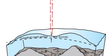
Scientists with the European Space Agency (ESA) have recently figured out that the laser altimeter instrument on the CryoSat satellite can be used to measure sea levels as well. Originally, the device was create to measure sea and land ice thickness and height.
CryoSat is the second vehicle ordered by ESA, since the first one failed during launch. The new spacecraft was built by main contractor EADS Astrium, and was launched aboard a Dnepr-1 delivery system from Baikonur Site 109/95, on April 8, 2010.
The 750-kilogram (1,700-pound) vehicle is scheduled to remain in Earth's orbit until at least 2013, though the mission may be extended beyond that time. Its primary aim is to provide scientists with a better understanding of polar and mountaintop ices.
Its focus is sea-ice thickness in Arctic regions, mission controllers say. In addition, the vehicle needs to keep an eye on changes that may affect the massive ice sheets covering Greenland and Antarctica. These are the two largest, land-based ice accumulations in the world.
If they melt, these ice sheets have the potential to raise global sea levels by several meters, endangering coastal cities such as Amsterdam, Tokyo, New York, Venice and many others. Tens of millions of people would be affected by this phenomenon, and ESA is dedicated to monitoring it.
However, it has been recently discovered that the laser altimeter CryoSat used to conduct its investigations can also study sea levels at any location. The vehicle can basically study ocean floor topography easily.
“The topography of the ocean surface mimics the rises and dips of the ocean floor due to the gravitational pull. Areas of greater mass, such as underwater mountains, have a stronger pull, attracting more water and producing a minor increase in ocean-surface height,” an ESA press release states.
“CryoSat’s radar altimeter can sense the gravity field at the ocean surface, so that seafloor characteristics at scales of 5–10 [kilometers, or 3.1 to 6.2 miles] are revealed. This is the first altimeter in 15 years to map the global marine gravity field at such a high spatial resolution,” the document adds.
Within 2 to 4 years, CryoSat will gather sufficient data to enable scientists to create a high-resolution map of the entire ocean floor. The dataset would be the most precise ever developed, at least 2 times more accurate than anything we have access to today.
“We know more about the surfaces of Venus and Mars than we do about the bathymetry of deep ocean. This new mapping from CryoSat will revolutionize our understanding of ocean floor tectonics and reveal, perhaps, 10 000 previously uncharted undersea volcanoes,” says David Sandwell.
He holds an appointment with the Scripps Institution of Oceanography (SIO), at the University of California in Davis.

 14 DAY TRIAL //