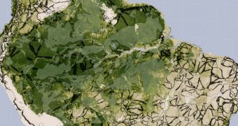
A group of investigators from the Woods Hole Research Center (WHRC) has recently added a new angle to the discussion about conservation efforts in general, and tropical forest conservation, in particular. The trio of scientists say that these efforts should be focused alongside strategic corridors that contain densely-vegetated and carbon-rich protected lands.
Their research is part of a wider-scale effort to offset carbon dioxide (CO2) emissions from industrialized nations and reduce the amount of forests given over to agriculture and development in emerging economies. The work was informed by a series of very troubling statistics covering forest usage and decline around the world.
Tropical forests currently cover 25 million square kilometers (9.65 million square miles) of Earth's surface, but they are spread over three continents and 75 countries. An estimated 225 to 250 billion tons of CO2 is stored in these forests, but around 1 billion tons of the greenhouse gas is released into the atmosphere every year via deforestation.
These emissions account for around 15 to 20 percent of the entire amount of CO2 released in the air every single year. Between 2000 and 2012, tropical rain forests have been lost at a rate of 90,000 square kilometers (35,000 square miles) annually. The WHRC team is now proposing a new way to ensure that biodiversity and environmental sustainability are promoted simultaneously.
The research group, including scientists Patrick Jantz, Scott Goetz, and Nadine Laporte, created the map above by combining socioeconomic data, ground-based surveys and NASA satellite imagery. The purpose of their study was to develop a new way of thinking when it comes to tropical conservation. This is important because these forests are home to around half of all terrestrial species on Earth.
In a nutshell, their proposal is to link forest and biosphere preserves via strategic corridors featuring densely forested protected lands. Implicitly, these lands contain vast amounts of carbon, which will no longer be released in the atmosphere via agriculture or urban development. Even very narrow corridors would significantly boost the genetic diversity and survival rates of many animal and plant species.
Animals and plants whose habitats are pressured by global warming and climate change would thus have access to an escape route, allowing them to move further north or south, or higher up, as needs dictate. The map above is centered on the large Amazon rainforests in South America, but similar datasets are available for forests in other parts of the world as well.
“Maintaining connectivity of forest ecosystems provides ecological and societal benefits. Corridors can help ensure long-term species survival, provide room for ecosystems to reorganize in response to climate change, and protect ecosystem resources that people depend on,” Jantz explains.
“To focus on corridors, as suggested by Jantz and colleagues, seems a promising solution. Corridors often yield benefits to biodiversity disproportionate to their size, by increasing population connectivity and providing safe routes for species to move with a changing climate, and could therefore offer a uniquely efficient way of increasing the biodiversity benefits of REDD+,” comments Oscar Venter.
The expert, a professor at the James Cook University, was not involved in the new study. REDD+ is an acronym for the United Nations' Reducing Emissions from Deforestation and Forest Degradation program, which currently seeks to reduce CO2 emissions and promote forest preservation worldwide.

 14 DAY TRIAL //