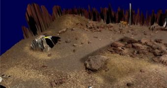
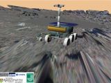
Experts at the Technical University of Prague Center for Machine Perception, under the direction of scientist Dr. Michal Havlena, have recently announced the development of a new computer system, capable of reproducing the Red Planet in 3D detail within minutes. The platform can also be fed images collected by exploration rovers such as the MER components or MRO, and it immediately integrates them into the larger view of things, its creators reveal. The instrument was unveiled at the European Planetary Science Congress, held in Potsdam, Germany, AlphaGalileo reports.
“The feeling of ‘being right there’ will give scientists a much better understanding of the images. The only input we need are the captured raw images and the internal camera calibration. After minutes of computation on a standard PC, a three dimensional model of the captured scene is obtained,” Dr. Havlena told participants at the conference. The system, he said, appeared as a help tool for experts who had to deal with impressive amounts of raw data coming in from all the Martian missions at the moment.
At this point, all of these pieces of information are processed manually, and this process consumes a lot of time and resources. Instead of doing repetitive tasks, experts who are now caught up in this work could instead dedicate their time to performing more interesting scientific tasks, the creators of the new platform believe. The instrument was created as part of the EU FP7 Project ProVisG, and allows for fast, high-quality image processing.
“The pipeline has already been used successfully to reconstruct a three dimensional model from nine images captured by the Phoenix Mars Lander, which were obtained just after performing some digging operation on the Mars surface. The challenge is now to reconstruct larger parts of the surface of the Red Planet, captured by the Mars Exploration Rovers Spirit and Opportunity,” the expert added. In order to compile its 3D renderings, the model relies on exploiting the disparities (parallaxes) that exist between images of the same objective, taken from two distinct camera positions.
The first stage in the combinatorial process is to scan an image, and then determine which other comes after it. The system does that by labeling, or tagging, each image with a number of visual words. After the first image is analyzed, the program shuffles through the others, until it finds the closest match, in terms of the number of visual words. The second step is a process called “structure-from-motion computation,” which determines the position of the cameras that took the photos accurately. The third step is the “dense 3D model generation,” which processes the disparities.

 14 DAY TRIAL //
