14 DAY TRIAL //
 The most recent analysis from experts at the US National Oceanic and Atmospheric Administration (NOAA) indicates that the month of September brought a wide array of climate irregularities to the United States. The change in patterns was not consistent throughout the country.
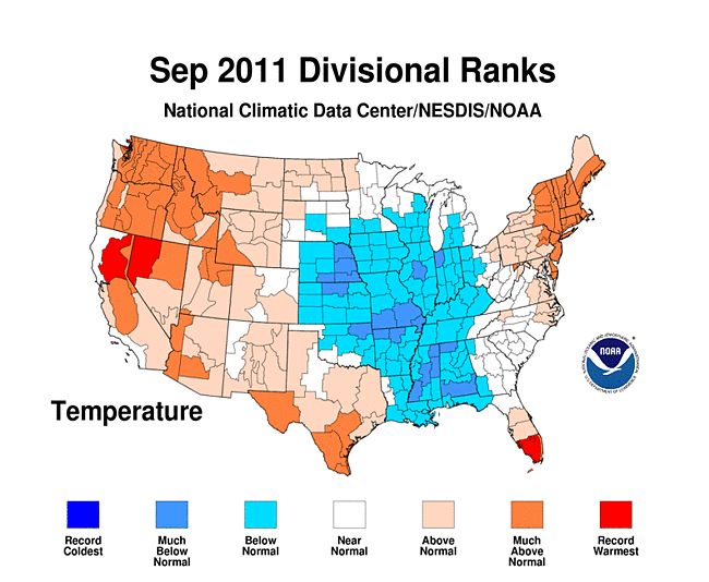
In fact, researchers say, the western and eastern parts of the country were subjected to above-average temperatures, whereas the central regions were subjected to colder-than-normal temperatures for this month. These differences puzzle climate scientists.
In addition, the team also found that the abnormally-high precipitation levels that drenched most of the eastern United States were caused by remnants of tropical storm Lee. But the heavy rains were beneficial in certain areas, such as in regions of the Gulf Coast that were plagued by drought.
Official measurements indicate an average temperature for the month of September around 66.9 degrees Fahrenheit, or about 19.3 degrees Celsius. This represents an 1.5ºF increase from the long-term average recorded between 1901 and 2000.
On average, the level of precipitation that drenched the country was around 2.43 inches (6.17 centimeters), a value that represents a slight decrease from the long-term average. Experts also found significant variation between different regions of the country.
“Above-normal temperatures dominated the western United States, with five states – California, Idaho, Nevada, Oregon, and Washington – having one of their ten warmest Septembers on record,” an official press release from NOAA reads.
“A persistent upper-level low pressure system was associated with 14 states having below-normal September temperatures across the central United States. Mississippi tied its ninth coolest September on record,” the statement adds.
The NOAA analysis also revealed that the bulk of precipitation that fell over the United States during last month originated in tropical storm Lee. The atmospheric event made landfall on September 4, on the Louisiana coast, and left up to 10 inches (25.4 centimeters) of rainfall in its wake.
“A string of eleven adjacent states from Louisiana to New York had a top ten wet September, partially attributable to tropical storm Lee. Across Pennsylvania, 9.71 inches fell during the month, 6.25 inches above average, marking the wettest September on record for the state,” the press release adds.
“Dry conditions prevailed across the Plains states. Kansas, Minnesota, Montana, South Dakota, and Texas had precipitation totals during September rank among their ten driest since 1895,” the statement concludes.