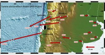
The magnitude 8.8 earthquake that struck Chile on February 27 was recently established to be the fifth-strongest in recorded history, and also one of the most interesting to study, from a geological perspective. It would appear that planetary scientists have a great deal to learn from it, and also from the changes that it caused to the planet. As we were telling you earlier, it apparently nudged our planet's figure axis off-course by a few inches, and experts now reveal that it also shifted entire cities several meters in specific directions.
The Chilean city of Concepcion had it worst off. Precise comparison of GPS measurements taken before and after the tremor appears to indicate that the entire urban center has been moved about 10 feet (roughly 3 meters) to the west of its initial location. Though this is the largest shift, given the city's proximity to the earthquake's epicenter, other major urban areas, including Buenos Aires, also got moved by a few inches. The Argentine city is more than 800 miles away, on the other side of the South American continent. It was also established that the Chilean capital Santiago moved 11 inches to the west as well, Wired reports.
“The Maule earthquake will arguably become one of the, if not the most important great earthquake yet studied. We now have modern, precise instruments to evaluate this event, and because the site abuts a continent, we will be able to obtain dense spatial sampling of the changes it caused. As such the event represents an unprecedented opportunity for the earth science community if certain observations are made with quickly and comprehensively,” says in a press release University of Hawaii expert Ben Brooks, who is also a scientists on the project which measured the effects of the tremor.
Most of the data in the new research come from a project that Ohio State University expert Mike Bevis has been conducting in Chile since 1993. The scientist and his team have been using GPS stations at various sites in the country to calculate precisely how the crust moves in the nation. These readings proved to be extremely useful for the new investigation, which had a starting point for its analysis. This specific area of the world's crust, where the Nazca Plate (a part of the Pacific Plate) meets the South American Plate, is one of intense activity, and a part of the infamous Pacific Ring of Fire. Researchers have been conducting studies here for many decades.

 14 DAY TRIAL //